


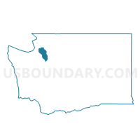
Austin Voting District, Island County, Washington
About
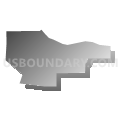
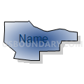
Outline

Summary
| Unique Area Identifier | 684482 |
| Name | Austin Voting District |
| County | Island County |
| State | Washington |
| Area (square miles) | 4.35 |
| Land Area (square miles) | 3.08 |
| Water Area (square miles) | 1.27 |
| % of Land Area | 70.79 |
| % of Water Area | 29.21 |
| Latitude of the Internal Point | 48.00203880 |
| Longtitude of the Internal Point | -122.53917620 |
Maps


Graphs
Select a template below for downloading or customizing gragh for Austin Voting District, Island County, Washington


Neighbors
Neighoring Voting District (by Name) Neighboring Voting District on the Map
- Bush Point 1 Voting District, Island County, WA
- Bush Point 2 Voting District, Island County, WA
- Double Bluff Voting District, Island County, WA
- Freeland Voting District, Island County, WA
- Lone Lake Voting District, Island County, WA
- Useless Bay 1 Voting District, Island County, WA
- Water: Admiralty Bay, Island County, WA
Top 10 Neighboring County Subdivision (by Population) Neighboring County Subdivision on the Map
- South Whidbey Island CCD, Island County, WA (13,630)
- Central Whidbey Island CCD, Island County, WA (12,458)
Top 10 Neighboring Place (by Population) Neighboring Place on the Map
Top 10 Neighboring Unified School District (by Population) Neighboring Unified School District on the Map
Top 10 Neighboring State Legislative District Lower Chamber (by Population) Neighboring State Legislative District Lower Chamber on the Map
Top 10 Neighboring State Legislative District Upper Chamber (by Population) Neighboring State Legislative District Upper Chamber on the Map
Top 10 Neighboring 111th Congressional District (by Population) Neighboring 111th Congressional District on the Map
Top 10 Neighboring Census Tract (by Population) Neighboring Census Tract on the Map
- Census Tract 9713, Island County, WA (4,393)
- Census Tract 9718, Island County, WA (2,452)
- Census Tract 9922.01, Island County, WA (0)